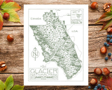
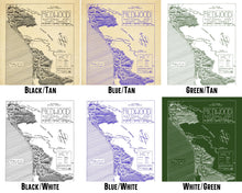
Welcome to Yosemite National Park. This is a high-quality art print of a handmade map which is hand-drawn with a fountain pen and ink.
Bisected by the US-Canada border, an astounding landscape and biosphere is protected by these twin parks: Glacier National Park to the south in the United States, and Waterton-Lakes National Park to the north in Canada. There's a sheer ruggedness, a sawtooth-like quality to the place which is impossible to describe. I live around mountains normally, but the mountains in Glacier and Waterton Lakes are on another level: when I first visited the parks in the summer of 2019, I was struck by how dynamic the landscape looked, how it seemed like the crust of the earth had been moving in fluid waves before being frozen in place. Explosively green vegetation grows on the mountains, with high-reaching pine forests, lush mountain valleys, and lakes colored with the impossibly deep blues and greens of glacial runoff, home to extraordinarily diverse wildlife.
In this map, I strove specifically to capture the overwhelming scale of the mountain ranges, as well as the numerous glacial lakes which emerge from between the jagged mountain peaks. I was surprised to find so many lodges, mountain chalets, and other little details scattered throughout the park, which were a ton of fun to draw and I did my best to represent them accurately. Glacier National Park and Waterton-Lakes National Park are truly unreal and special places, and it was a joy to create this map!
𝗗𝗲𝘁𝗮𝗶𝗹𝘀:
• The map was drawn using a LAMY fountain pen and ink with a high degree of detail, accurately captured in the art print.
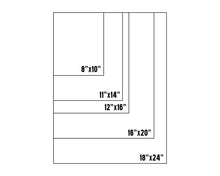
• It is printed on thick, durable matte paper. The paper is archival, acid-free paper that is 10.3 mil thick. The paper has a matte finish (not glossy). Printed in the USA.
• While directly based on the maps provided at NPS visitor centers, I would not recommend relying on this map as a sole means of navigation within the parks! Many details are hard to fit in (such as side roads and hiking trails) and liberties have been taken with portraying certain regions and landmarks.
• © Copyright 2021 by Cryptocartography


